Emergency Operations Update – June 3, 2020 – 4:00 PM
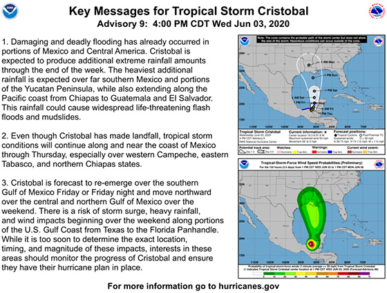
Fort Bend County Levee Improvement District No. 2 (FBCLID 2) is actively monitoring Tropical Storm Cristobal in the Gulf of Mexico. The latest National Hurricane Center forecast is included below. The probable path of Tropical Storm Cristobal currently includes the Texas coast and predicts potential impacts could start by Sunday, June 7. The FBCLID 2 pump stations have been tested and operators are on stand-by to run the pumps, if needed. Fortunately, the Brazos River and Ditch H are at low levels that do not impact drainage inside the FBCLID 2 levee.
FBCLID 2 recently launched a new Emergency Operations Website. The webpage continually streams live information about rainfall and water levels in the area. All the information is intended to increase awareness during emergencies and help inform decision-making for residents.
FBCLID2.COM/EMERGENCY features include:
- Live graphic of levee operations
- 24-hour rainfall total
- Ditch water levels inside and outside the levee
- Brazos River Forecast (if flood stages are predicted)
- Pump Station operations
- Rainfall & stream gauges
- Live camera views with hourly updates
- Links to City of Sugar Land and Fort Bend County Emergency Management
FBCLID2.com/alerts
Residents are encouraged to sign up for email and text alerts through the District’s website to stay up-to-date on the latest news.