Flood Insurance Discounts in FBCLID 2

Fort Bend County Levee Improvement District No. 2 (FBCLID 2) recommends that all residents consider purchasing flood insurance and discuss available options with your insurance provider. In 2021, Federal Emergency Management Agency (FEMA) implemented Risk Rating 2.0 (RR2.0) and changed how National Flood Insurance Program (NFIP) flood insurance rates are calculated for your home and property. However, when FEMA implemented RR2.0, FBCLID 2 residents were not receiving the same flood insurance discounts that were applied in other parts of Sugar Land.

All homes in FBCLID 2 remain eligible to participate in the NFIP and beginning in 2025 these flood insurance policies included a new discount. The City of Sugar Land participates in the NFIP Community Rating System (CRS) and currently holds a Class 6 CRS rating, which lowers flood insurance premiums by 20%. When renewing your flood insurance policy, please check the NFIP Community Number (CID); in Sugar Land and FBCLID 2, the CID should be “480234”. Should your policy indicate something other than the “Class 6” rating, and your property is within the Sugar Land city limits, please call your insurance agent to correct the error. The formal NFIP notification from FEMA is posted for reference.

FBCLID2 is working to further reduce flood insurance premiums by participating in a United States Army Corps of Engineers (USACE) risk assessment. The USACE risk assessment was performed in April, and the results will be incorporated into FEMA’s RR2.0 flood insurance calculations as soon as October 2026. Based upon preliminary USACE results, FBCLID2 residents should expect to receive additional NFIP flood insurance discounts moving forward.

Rainfall and Brazos River Forecast: June 15, 2026

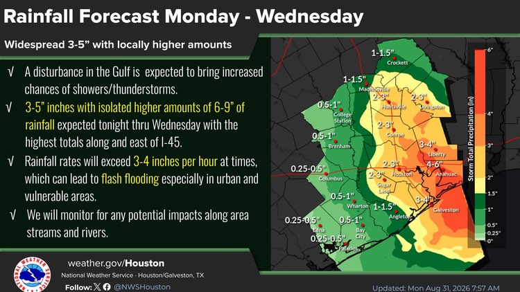
The Brazos River is forecasted to crest at 39.9 feet at the Richmond Gage on Friday, June 19. At this elevation, the Fort Bend County Levee Improvement District No. 2 (LID 2) flood gates can close and impact gravity drainage inside the levee. LID 2 is also forecasted to receive 4-7 inches of rainfall through Wednesday, and isolated totals over 10 inches are possible. Fortunately, the risk of heavy rainfall decreases later this week when the Brazos River elevation is high enough to close the flood gates. The LID 2 pump stations have been tested and operators are on stand-by, if needed. LID 2 residents are encouraged to bookmark the Emergency Operations website to receive the latest information: FBCLID2.com/EMERGENCY.

The latest forecast information from the National Weather Service is linked below. During any heavy rain event there may be street ponding or flooding if the storm drains are overwhelmed and back up. As rainfall decreases, the storm sewers will catch up, and any water in the streets will recede. Never drive into high water.

Brazos River at Richmond, TX

National Weather Service

Emergency Operations Update: Brazos River Forecast – June 9, 2026

The Brazos River is forecasted to crest at 32.3 feet at the Richmond Gage on Thursday, June 11.  At this elevation the Fort Bend County Levee Improvement District No. 2 (LID 2) drainage system continues to operate normally with gravity flow. Fortunately, LID 2 is forecasted to receive less than ¼” of rain over the next 5 days while the Brazos River is elevated. However, LID 2 is prepared if the situation changes. The pump stations have been tested and operators are on stand-by, if needed. LID 2 residents are encouraged to bookmark the Emergency Operations website to receive the latest information: FBCLID2.com/EMERGENCY. The latest forecast information from the National Weather Service is linked below.

Brazos River at Richmond, TX

National Weather Service

Rainfall Forecast