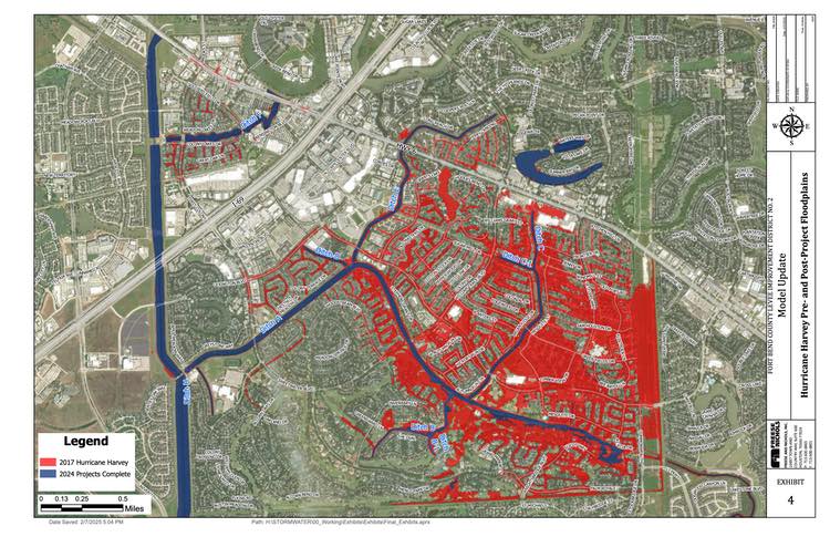
Texas Flood Awareness Week – May 23-27, 2022

As members of the Texas Floodplain Management Association (TFMA), FBCLID 2 would like to remind all residents that May 23-27 is Texas Flood Awareness Week.  With Hurricane Season just around the corner, FBCLID 2 encourages all residents to bookmark the Emergency Operations website: https://www.fbclid2.com/emergency.

A variety of information is automatically updated to increase flood awareness during emergencies and help inform decision-making for residents.  The FBCLID 2 Emergency Operations website now includes a link to the City of Sugar Land’s award-winning Integrated Storm Water Management Model (ISWMM). The City of Sugar Land developed ISWMM to assist in forecasting ponding in the City.  ISWMM utilizes 28 rain/stream gages across the City to collect real-time rainfall data and stream data to predict street ponding depths.

FBCLID 2 Emergency Operations website:

  • Levee operations graphic
    • 24-hour rainfall total
    • Water levels inside and outside the levee
    • Brazos River Forecast (if flood stages are predicted)
    • Pump Station operations
  • Rainfall & stream gauges
  • City of Sugar Land ISWMM
  • Camera views with hourly updates
  • Links to City of Sugar Land and Fort Bend County Emergency Management

FBCLID 2 residents are also encouraged to sign up for email and text alerts and receive the latest information directly from the District: www.fbclid2.com/alerts

Emergency Operations Update – Tropical Storm Nicholas

8:02 AM

Fort Bend County Levee Improvement District No. 2 (FBCLID 2) is actively monitoring Tropical Storm Nicholas in the Gulf of Mexico.  The latest forecast and information from the National Weather Service is included below.  The probable path of Tropical Storm Nicholas includes FBCLID 2 with a 50-60% probability of Tropical Storm Force winds (39+ MPH).  The District is currently forecasted to receive 5-10 inches of rain.

Fortunately, the Brazos River and Ditch H are at low levels that do not impact drainage inside the FBCLID 2 levee. The FBCLID 2 pump stations have been tested and operators are available to run the pumps, if needed.  Four new pumps at the Third Pump Station are also operational, and each new pump can remove 190,000 gallons of water per minute (GPM).  When combined with the existing Bill Little Pump Station, this represents more than 1,000,000 GPM of available pump capacity.  In addition, Phase I of the Ditch A Widening Project recently added more than 50 acre-feet of flood storage inside the FBCLID 2 levees.

National Hurricane Center
National Weather Service

FBCLID2.com/emergency:

  • Live graphic of levee operations
    • 24-hour rainfall total
    • Ditch water levels inside and outside the levee
    • Brazos River Forecast (if flood stages are predicted)
    • Pump Station operations
  • Rainfall & stream gauges
  • Live camera views with hourly updates
  • Links to City of Sugar Land and Fort Bend County Emergency Management

FBCLID2.com/alerts:
Residents are encouraged to sign up for email and text alerts through the District’s website to stay up-to-date on the latest news.

Emergency Operations Update – Tuesday, June 1, 2021

The Brazos River is currently at a river stage of 35.3 feet, but that level is forecasted to increase to 42.8 feet by Sunday, June 6.  The latest forecast does not include a crest, so the final Brazos River stage may exceed 42.8 feet.  At this elevation, the Brazos River begins to close the flood gates in the levee and restrict drainage inside FBCLID 2.  The District’s pump stations were operated over the Memorial Day weekend to remove rainfall, and they will continue to maintain as much flood storage as possible inside the levee.  The current forecast calls for 4-6 of rain over the next 7 days, and the operators remain on stand-by to run the pumps.  The latest forecast and information from the National Weather Service is included below.

For additional information on FBCLID 2 Emergency Operations: FBCLID2.com/emergency

  • Live graphic of levee operations
    • 24-hour rainfall total
    • Ditch water levels inside and outside the levee
    • Brazos River Forecast (if flood stages are predicted)
    • Pump Station operations
  • Rainfall & stream gauges
  • Live camera views with hourly updates
  • Links to City of Sugar Land and Fort Bend County Emergency Management

Brazos River Gage at Richmond, Texas
National Weather Service