Emergency Operations Update – Tuesday, May 18, 2021

The Brazos River is forecasted to crest at 43.6 feet at the Richmond Gage on Sunday, May 23.  At this elevation, the FBCLID 2 flood gates begin to close and drainage inside the levee is restricted.  The FBCLID 2 pump stations have been tested, and operators are on stand-by to run the pumps, if needed.  The forecast calls for 6 to 8 inches of rain within the District through Thursday, with isolated areas in the area potentially receiving as much as 10-12 inches.  However, most of the forecasted rain will have time to drain out of the levee before any pumping is required.  The latest forecast and information from the National Weather Service is included below.

For additional information on FBCLID 2 Emergency Operations: FBCLID2.com/emergency

  • Live graphic of levee operations
    • 24-hour rainfall total
    • Ditch water levels inside and outside the levee
    • Brazos River Forecast (if flood stages are predicted)
    • Pump Station operations
  • Rainfall & stream gauges
  • Live camera views with hourly updates
  • Links to City of Sugar Land and Fort Bend County Emergency Management

National Weather Service

Brazos River Gage at Richmond, Texas

Live Photo Updates – Emergency Operations

The FBCLID 2 Emergency page was just updated to include additional live cameras. Updated images are posted hourly at: www.fbclid2.com/emergency

New camera views include:

  • Interior Drainage Channels (Ditch A and C)
  • Steep Bank Creek outfall at East Levee
  • Oyster Creek at Dam 3

Existing FBCLID 2 Emergency features include:

  • Emergency Operations graphic
  • Brazos River & Ditch H water level outside the levee
  • Ditch A water level inside the levee
  • Bill Little Pump Station operations
  • FBCLID 2 critical elevations for levees, homes, and streets
  • Graphic displays “live” values and automatically updates
  • Rain and Stream Gauges
  • Rainfall totals
  • Drainage Channel water levels
  • Hourly photo updates of staff gauges inside and outside levee

Coming Soon!

  • Hourly photo updates of Williams Trace Blvd. at Ditch C-1 and Austin Parkway at 3 locations.

Emergency Operations Update – Tropical Storm Hanna Update

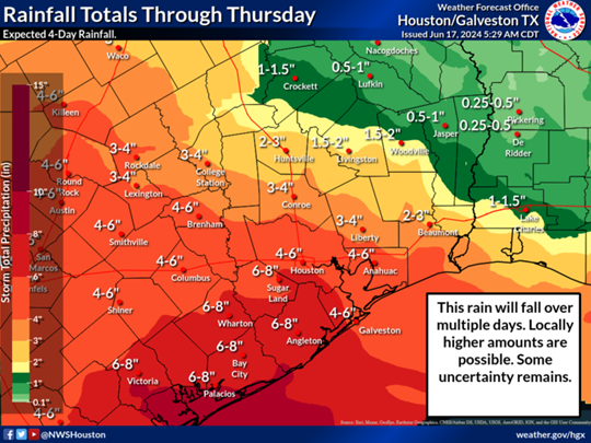
Fort Bend County Levee Improvement District No. 2 (FBCLID 2) continues to monitor Tropical Storm Hanna in the Gulf of Mexico. The FBCLID 2 pump stations have been tested and operators are on stand-by to run the pumps, if needed. Fortunately, the Brazos River and Ditch H are at low levels that do not impact drainage inside the FBCLID 2 levee. The latest forecast and information from the National Weather Service is included below:

“Tropical Storm Hanna is continuing to develop and move westward. We can expect increasing winds and seas across the Upper Texas Coastal waters today, and the threat of heavy rainfall spreading into Southeast Texas today and lingering through Sunday.…”

National Hurricane Center
National Weather Service


FBCLID2.com/emergency:

  • Live graphic of levee operations
    • 24-hour rainfall total
    • Ditch water levels inside and outside the levee
    • Brazos River Forecast (if flood stages are predicted)
    • Pump Station operations
  • Rainfall & stream gauges
  • Live camera views with hourly updates
  • Links to City of Sugar Land and Fort Bend County Emergency Management

FBCLID2.com/alerts
Residents are encouraged to sign up for email and text alerts through the District’s website to stay up-to-date on the latest news.