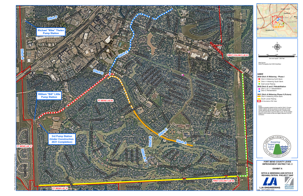
Emergency Operations Update – 9:00 AM

Fort Bend County Levee Improvement District No. 2 (FBCLID 2) is actively monitoring tropical activity in the Gulf of Mexico. Sugar Land is expected to receive several inches of rain throughout the week. Fortunately, the Brazos River is at extremely low levels that do not impact drainage inside the FBCLID 2. When the Brazos River is low the flood gates remain open allowing all runoff to drain out of the levee. The FBCLID 2 pump stations remain operational and staffed if conditions change this week. The Emergency Operations graphic describes the current status and water elevations for FBCLID2.

Email & Text Alerts

Residents are encouraged to sign up for email and text alerts through the District’s website to stay up-to-date on the latest news.

Flood Monitoring System

Flood gauges that monitor rainfall and ditch water levels.

FBCLID 2 Map

Locate your home and FBCLID 2 Levees, Ditches, and Pump Stations.

Additional Emergency Management Information

Third Pump Station Construction Update

On Wednesday, August 7th, Fort Bend County Levee Improvement District No. 2 (FBCLID 2) awarded the first construction contract for the Third Pump Station to Jerdon Enterprise.  Construction activity is expected to begin at the north end of Oakland Dr. in late-August.  This first construction contract will prepare the project site for construction by removing existing structures, installing construction access and security, and preparing for multiple utility relocations.  Six different utilities will need to be relocated during the fall of 2019 to accommodate pump station construction.  The first phase of construction and the utility relocations are scheduled to be complete by November.

The second phase of construction, the largest phase of the project, addresses installation of the actual pump station.  The final pump station design is now complete and bids for this second phase of construction will be opened on Friday, September 30.  FBCLID 2 plans to award the Third Pump Station construction contract in October.  The contractor will then mobilize in November as soon as the first phase of construction is complete, and the site is ready.

The Third Pump Station will operate seven large storm water pumps that are powered by 1,500-horsepower motors.  When combined all seven pumps can move approximately 1,000,000 gallons of water per minute which represents a 400% increase in pumping capacity.  The seven pumps and motors require a very long lead time to design and manufacture.  To expedite completion of the Third Pump Station, the contract to manufacture the pumps and motors was awarded back in April 2019.

The attached graphic demonstrates how the Third Pump Station will improve FBCLID 2 drainage.  The chart shows water levels inside the FBCLID 2 levee during Hurricane Harvey and more recently during the May 7, 2019 flood.  The chart also displays the water levels inside the levee if the Third Pump Station was operational during each event. Additional details about the Third Pump Station are available on line at www.fbclid2.com/resource-center/.

The Third Pump Station construction site is at the north end of Oakland Dr. and will be accessed via Sweetwater Blvd. and Elkins Rd.  FBCLID 2 recognizes this is a major construction project occurring inside a residential neighborhood.  The pump station design addresses these constraints and concerns as much as possible.  However, the nature of the project requires thousands of hours of major construction activity including large construction vehicles carrying equipment and materials in and out of the neighborhood.  The Third Pump Station is currently scheduled to be complete and operational by Spring 2021.

For additional FCBLID 2 information:
Website: www.fbclid2.com
Email: gm1@fbclid2.com
Phone: 713-574-5261

Emergency Operations Update June 5, 2019 – 10:00 AM

Fort Bend County Levee Improvement District No. 2 (FBCLID 2) is actively monitoring tropical activity that has moved into Sugar Land overnight. Rain is expected to continue throughout the day on Wednesday, June 5th. Currently 1.5 inches of rainfall has fallen inside the levee, with the potential for more rain throughout the day. The FBCLID 2 pump stations are operating normally to remove the water from inside the levee. Fortunately, the Brazos River and Ditch H are significantly lower than they were during the flooding experienced last month (May 2019). The water level outside the levee is 15 feet lower which allows the drainage system to function more efficiently if FBCLID 2 receives more intense rainfall. The Emergency Operations graphic describes the current status and water elevations for FBCLID2.

Email & Text Alerts:
Residents are encouraged to sign up for email and text alerts through the District’s website to stay up-to-date on the latest news: https://www.fbclid2.com/sign-up-for-email-or-text-message-alerts/

Flood Monitoring System:
Flood gages that monitor rainfall and ditch water levels are located at: www.fbclid2.com/gauges

FBCLID 2 Map:
Locate your home and FBCLID 2 Levees, Ditches, and Pump Stations: www.fbclid2.com/map

Additional Emergency Management Information: