Emergency Operations Update – 9:00 AM

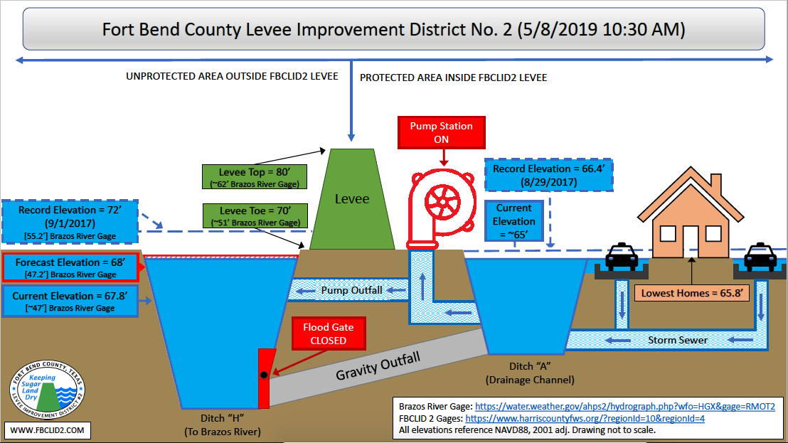
Fort Bend County Levee Improvement District No. 2 (FBCLID 2) is actively monitoring tropical activity in the Gulf of Mexico. Sugar Land is expected to receive several inches of rain throughout the week. Fortunately, the Brazos River is at extremely low levels that do not impact drainage inside the FBCLID 2. When the Brazos River is low the flood gates remain open allowing all runoff to drain out of the levee. The FBCLID 2 pump stations remain operational and staffed if conditions change this week. The Emergency Operations graphic describes the current status and water elevations for FBCLID2.

Email & Text Alerts

Residents are encouraged to sign up for email and text alerts through the District’s website to stay up-to-date on the latest news.

Flood Monitoring System

Flood gauges that monitor rainfall and ditch water levels.

FBCLID 2 Map

Locate your home and FBCLID 2 Levees, Ditches, and Pump Stations.

Additional Emergency Management Information

Emergency Operations Update June 5, 2019 – 10:00 AM

Fort Bend County Levee Improvement District No. 2 (FBCLID 2) is actively monitoring tropical activity that has moved into Sugar Land overnight. Rain is expected to continue throughout the day on Wednesday, June 5th. Currently 1.5 inches of rainfall has fallen inside the levee, with the potential for more rain throughout the day. The FBCLID 2 pump stations are operating normally to remove the water from inside the levee. Fortunately, the Brazos River and Ditch H are significantly lower than they were during the flooding experienced last month (May 2019). The water level outside the levee is 15 feet lower which allows the drainage system to function more efficiently if FBCLID 2 receives more intense rainfall. The Emergency Operations graphic describes the current status and water elevations for FBCLID2.

Email & Text Alerts:
Residents are encouraged to sign up for email and text alerts through the District’s website to stay up-to-date on the latest news: https://www.fbclid2.com/sign-up-for-email-or-text-message-alerts/

Flood Monitoring System:
Flood gages that monitor rainfall and ditch water levels are located at: www.fbclid2.com/gauges

FBCLID 2 Map:
Locate your home and FBCLID 2 Levees, Ditches, and Pump Stations: www.fbclid2.com/map

Additional Emergency Management Information:

Emergency Operations Summary – May 14, 2019

  • Last week FBCLID 2 received 10-13 inches of rainfall in just a few days. The majority of the rain occurred on Tuesday, May 10 with some areas receiving more than 6 inches of rain in under 2 hours.  The intensity of these rainfall rates exceeds any previously measured in FBCLID 2, including during Hurricane Harvey.  While all this rain was falling, the Brazos River was also at elevated levels that automatically close the flood gates in the levee.  When this occurs, all rainfall must by pumped out of the levee.  The FBCLID 2 pump stations operated continuously during the event and there were no problems or issues with the pumps.
  • In contrast, during Hurricane Harvey, FBCLID 2 received more than 30 inches of rainfall. While the total amount of rain was far greater, the intensity of rainfall did not approach the incredible rates experienced last week.  Rainfall during Harvey was also spread out over 5 days and not concentrated into a few hours.  When Harvey made landfall, the Brazos River was very low so the majority of the 30 inches of rainfall flowed out of the levee by gravity and did not require pumping.
  • The attached chart displays the water levels inside the FBCLID 2 levee during Hurricane Harvey and the recent May 2019 flood. The chart also displays rainfall rates during both events measured in 15-minute increments.  The two horizontal black lines approximate the elevations where street flooding and home flooding occur.
  • Since Hurricane Harvey, FBCLID 2 studied the causes of and solutions to flooding inside the levee. Design and construction have already started on several improvement projects.  The project that will provide the most benefit during future storms of this nature is the addition of a Third Pump Station at the end of Ditch A (generally located behind Clements High School).  The dashed red and blue lines on the attached chart estimate the water levels inside the levee if the Third Pump Station was operating during Hurricane Harvey and May 2019.
  • A project schedule for construction of the Third Pump Station is attached. FBCLID 2 is more than a year into design.  The required property for the Third Pump Station has been acquired, and the new pumps have already been ordered.  The new pumping facility will be constructed around seven pumps with 1500 horsepower motors that can pump a combined 980,000 gallons per minute.  The project is currently scheduled for completion in Spring 2021.  The existing pump station on Ditch A has a capacity of 241,800 gallons per minute.
  • A series of projects are also being designed and constructed to improve drainage and increase rainfall storage inside the levee. A construction project to perform maintenance and channel improvements to Ditches B, C and E is already underway.  A project to widen Ditch A and increase its storage capacity is entering design.  FBCLID 2 is also looking to partner with Fort Bend ISD and/or Sweetwater Country Club to provide additional storage for runoff during the most extreme rain events.