Emergency Operations Update June 4, 2019 – 10:00 AM
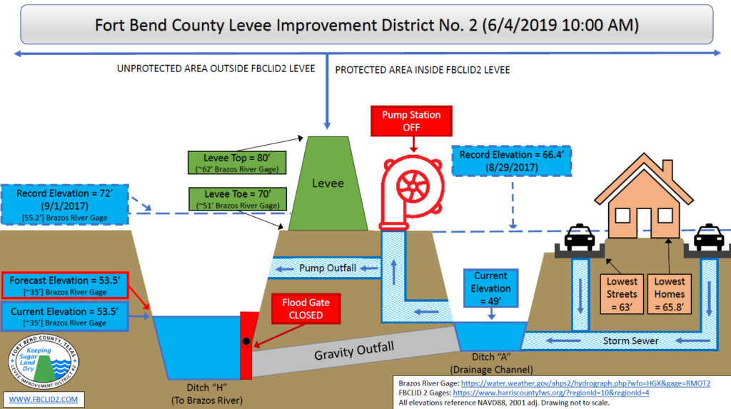
Fort Bend County Levee Improvement District No. 2 (FBCLID 2) is actively monitoring tropical activity in the Gulf of Mexico that is forecasted to impact Sugar Land overnight and throughout the day on Wednesday, June 5th. Currently 4-6 inches of rainfall is forecasted through Thursday, June 6th. The Emergency Operations graphic describes the current status and water elevations for FBCLID2.
The current Brazos River gage reading is approximately 35 feet and is forecasted to stay at that level through the weekend. The water elevation in Ditch H created by the Brazos River will remain more than 15 feet below the bottom of the FBCLID2 levee. However, this water level outside the levee can restrict the gravity drainage of rainfall inside the levee. If FBCLID 2 does receive heavy rainfall the internal drainage ditches have been pumped down to maximize storage capacity. Also, the Bill Little and Mike Thelen Pump Stations are both fully operational and staffed.
Email & Text Alerts:
Residents are encouraged to sign up for email and text alerts through the District’s website to stay up-to-date on the latest news: https://www.fbclid2.com/sign-up-for-email-or-text-message-alerts/
Flood Monitoring System:
Flood gages that monitor rainfall and ditch water levels are located at: www.fbclid2.com/gauges
FBCLID 2 Map:
Locate your home and FBCLID 2 Levees, Ditches, and Pump Stations: www.fbclid2.com/map
Additional Emergency Management Information:


