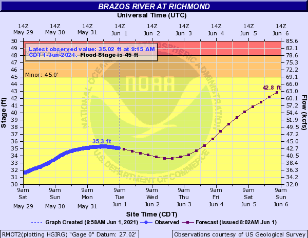
The Brazos River is currently at a river stage of 35.3 feet, but that level is forecasted to increase to 42.8 feet by Sunday, June 6. The latest forecast does not include a crest, so the final Brazos River stage may exceed 42.8 feet. At this elevation, the Brazos River begins to close the flood gates in the levee and restrict drainage inside FBCLID 2. The District’s pump stations were operated over the Memorial Day weekend to remove rainfall, and they will continue to maintain as much flood storage as possible inside the levee. The current forecast calls for 4-6 of rain over the next 7 days, and the operators remain on stand-by to run the pumps. The latest forecast and information from the National Weather Service is included below.
For additional information on FBCLID 2 Emergency Operations: FBCLID2.com/emergency
- Live graphic of levee operations
- 24-hour rainfall total
- Ditch water levels inside and outside the levee
- Brazos River Forecast (if flood stages are predicted)
- Pump Station operations
- Rainfall & stream gauges
- Live camera views with hourly updates
- Links to City of Sugar Land and Fort Bend County Emergency Management
Brazos River Gage at Richmond, Texas
National Weather Service